
|
2016/17 Food Security Map for Zambia
|
Zambia
|
Food Security & Agriculture, GIS & Mapping, Risk Identification & Assessment
|
|
|
|
Climatological Atlas of Madagascar
|
Madagascar
|
Climate Change, GIS & Mapping, Information Management
|
|
|

|
Atlas of Sectorial Vulnerability of the Atsimo Andrefana Region
|
Madagascar
|
Climate Change, Food Security & Agriculture, GIS & Mapping, Health & Health Facilities, Infrastructure, Urban Risk & Planning, Vulnerable Populations
|
Cyclone, Drought, Flood
|
|

|
Atlas of Sectorial Vulnerability of the Sava Region
|
Madagascar
|
Climate Change, Food Security & Agriculture, GIS & Mapping, Health & Health Facilities, Infrastructure, Risk Identification & Assessment, Urban Risk & Planning, Vulnerable Populations
|
Cyclone, Drought, Flood
|
|

|
Atlas of Risks of the Sofia Region
|
Madagascar
|
Climate Change, Vulnerable Populations
|
Cyclone, Drought, Flood
|
|

|
Flood Risk - Gwayi Catchment
|
Zimbabwe
|
Climate Change
|
Flood
|
|

|
Flood Risk - Manyame Catchment
|
Zimbabwe
|
Climate Change, Disaster Risk Management, Environment, GIS & Mapping, Risk Identification & Assessment
|
Flood
|
|
|
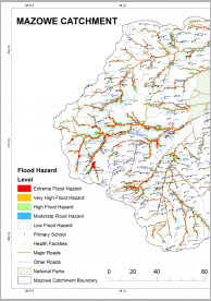
Flood Risk - Mazowe Catchment
|
Zimbabwe
|
Climate Change, Disaster Risk Management, Environment, GIS & Mapping, Risk Identification & Assessment
|
Flood
|
|

|
Flood Risk - Mzingwane Catchment
|
Zimbabwe
|
Climate Change, Disaster Risk Management, Environment, GIS & Mapping, Risk Identification & Assessment
|
Flood
|
|

|
Flood Risk - Runde Catchment
|
Zimbabwe
|
Climate Change, Disaster Risk Management, Environment, GIS & Mapping, Risk Identification & Assessment
|
Flood
|
|